

The CFTI (Advanced Laboratory of Historical Seismology) portal by Istituto Nazionale di Geofisica e Vulcanologia (INGV) was designed with the target of building a dynamic archive that makes available to a wide specialist and non-specialist public – scholars, civil protection officers, teachers, students, professionals, simple onlookers – the IT tools that today allow the analysis of the data provided by the Catalogue of Strong Earthquakes in Italy in its most advanced version.
We hope that it will promote a better understanding not only of seismicity, but also of the long-term social, economic and cultural response to the occurrence of strong earthquakes. Therefore, and due to the inherent nature of this portal, we may anticipate new advancements, the exploration of new topics and new disciplinary intersections.
| |
With the exception of the publications (books, articles and web products), for each of which the reader must refer to the specific user license indicated by their publisher, all data on this portal are offered with a Creative Commons Attribution 4.0 International license (CC BY 4.0). This license requires that any reutilization of data from this portal must give the necessary credit to: |
This portal has been designed and developed by Gabriele Tarabusi ![]() with the contribution of Rita Chiara Taccone
with the contribution of Rita Chiara Taccone ![]() (technical and system support).
(technical and system support).
The main contributors to the portal are indicated in this section.
For further info please refer to: cfti@ingv.it
Il portale CFTI (Laboratorio Avanzato di Sismologia Storica) dell'Istituto Nazionale di Geofisica e Vulcanologia (INGV) è stato ideato e realizzato con l'obiettivo di costruire un archivio dinamico che mette a disposizione di un ampio pubblico specialistico e non – studiosi, funzionari di protezione civile, insegnanti, studenti, professionisti, semplici curiosi – gli strumenti informatici che oggi permettono l'analisi dei dati forniti dal Catalogo dei Forti Terremoti in Italia nella sua versione più avanzata.
Ci auguriamo che possa favorire una migliore comprensione non solo della sismicità, ma anche delle risposte sociali, economiche e culturali date ai forti terremoti nel lungo periodo. Non mancheranno quindi avanzamenti, esplorazioni e nuove intersezioni tematiche.
| |
Ad eccezione delle pubblicazioni (libri, articoli e prodotti web) per ciascuna delle quali si rimanda alla specifica licenza d'uso indicata, i dati presenti in questo portale sono proposti con licenza Creative Commons Attribuzione 4.0 Internazionale (CC BY 4.0), per cui, per ogni utilizzo, è sempre richiesto di riportare la seguente citazione: |
Questo portale è stato progettato e sviluppato da Gabriele Tarabusi ![]() con il supporto tecnico e sistemistico di Rita Chiara Taccone
con il supporto tecnico e sistemistico di Rita Chiara Taccone ![]() e la consulenza del Laboratorio Grafica e Immagini di INGV.
e la consulenza del Laboratorio Grafica e Immagini di INGV.
I principali contributori del portale sono indicati in questa sezione.
Per Informazioni e contatti: cfti@ingv.it
This portal was designed as "work in progress", and as such it is open to later additions and improvements. For these reasons and due to its intrinsic nature of repository of information on complex natural phenomena, it cannot be guaranteed to be complete, accurate and updated in any part, and will be subjected to successive revisions. Although the authors make every effort to supply the best available information on the historical earthquakes contained in it, no warranty, expressed or implied, is provided as to the accuracy and reliability of all the data supplied.
Users are cautioned to consider carefully the nature of the information supplied by this portal before using it for decisions that concern personal and public safety, or in relation with business involving substantial financial or operational consequences.
Any conclusions drawn from this portal, or actions undertaken on the basis of its contents, are the sole responsibility of the user.
Part of the activities of technological development and data reorganization that led to the implementation of several contents of the portal has been supported by a grant from Italy’s Presidenza del Consiglio dei Ministri-Dipartimento della Protezione Civile. Nevertheless, the views and conclusions reported in the CFTIare the sole responsibility of its authors, and should not be interpreted as necessarily representing official policies, either expressed or implied, of the Dipartimento della Protezione Civile.
Questo portale è stato progettato come un work in progress, e come tale prevede di essere progressivamente arricchito con nuovi dati o rettificato se necessario. Per questa ragione, oltre che per la sua stessa natura di grande archivio dinamico di dati su fenomeni naturali complessi, quali sono i terremoti, le eruzioni vulcaniche e i maremoti, non è possibile garantirne la totale completezza. Gli autori sono impegnati a continuare a fornire informazioni sempre più aggiornate e approfondite sui terremoti storici descritti, ma non possono fornire alcuna garanzia sull'accuratezza e l'affidabilità dei dati forniti.
L'utente deve tenere ben presente la natura delle informazioni fornite dal presente portale prima di utilizzarle per decisioni che possono riguardare la sicurezza delle persone o che possono avere gravi conseguenze finanziarie e operative.
L'utente è quindi tenuto ad assumersi tutte le responsabilità che possono derivare da sue personali conclusioni e scelte basate sui dati del CFTI.
Parte delle attività di sviluppo tecnologico e di riorganizzazione dei dati realizzate per la pubblicazione di diversi contenuti del portale CFTI ha beneficiato del contributo finanziario della Presidenza del Consiglio dei Ministri – Dipartimento della Protezione Civile; rimane degli autori la responsabilità dei contenuti, che pertanto non riflettono necessariamente la posizione e le politiche ufficiali del Dipartimento.
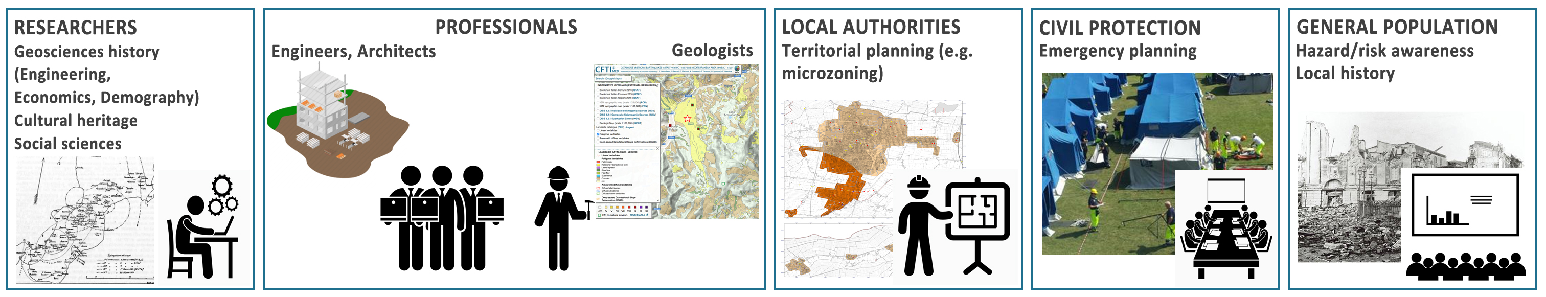
I contenuti presenti in questo portale si rivolgono a una vasta platea di potenziali utilizzatori, che include:
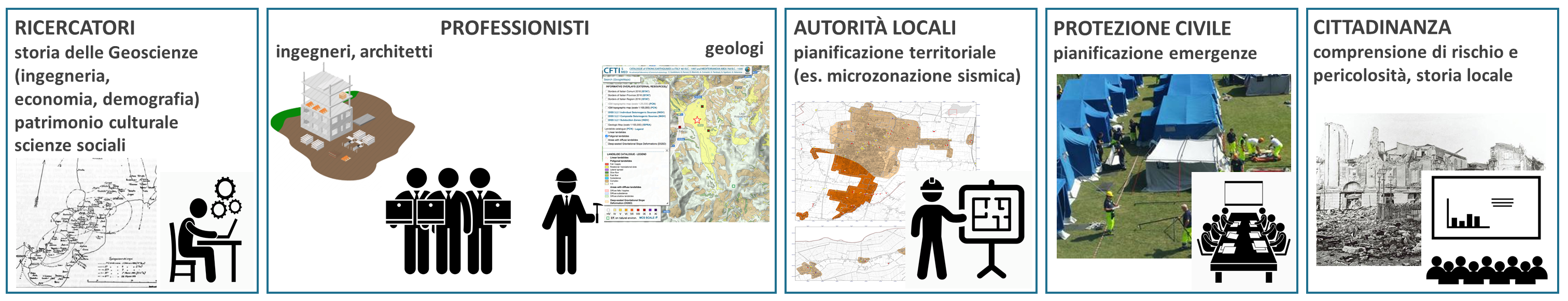
The contents of this portal are addressed to a large audience of potential users, which includes:
")
")
È un catalogo di nuova generazione e analitico che accoglie i risultati di quattro decenni di ricerca in Sismologia Storica in Italia e nell’area mediterranea.
Di nuova generazione, perché presenta solo risultati di ricerche di base originali, sviluppate alla luce di una nuova sensibilità storiografica, con una impostazione metodologica che punta a garantire trasparenza alla ricerca e oggettività alla relativa interpretazione sismologica.
Analitico, perché per la maggior parte dei terremoti analizzati presenta sintesi descrittive sia dei loro effetti in ogni singola località, sia del loro impatto sociale ed economico. Per ogni sequenza sismica studiata fornisce inoltre una bibliografia completa di tutte le testimonianze di studiosi o osservatori occasionali, moltissime delle quali sono fornite on-line in originale o come trascrizione.
CFTI is a new generation and an analytical catalogue that stores the results of four decades of research in Historical Seismology on Italy and on the Mediterranean area.
It is new generation, as it presents results of original basic research only. The research was developed in the light of a new historiographic sensitivity, based on a methodological approach that makes all the work done fully transparent while ensuring the objectivity of the resulting seismological interpretations.
It is also analytical, because for most of the analyzed earthquakes it features descriptive summaries of both the effects of each specific event at each individual location and of its overall social and economic impact. In addition, for each investigated earthquake sequence it provides a complete bibliography of all testimonies of scholars and casual observers; many of such documents are supplied on-line, either in the form of the original source or as a transcription.
Nel corso di circa quattro decenni di studio dei terremoti storici italiani sono state reperite molte fonti visive (incisioni, dipinti, fotografie, documenti cinematografici ecc.) che possono essere utili agli studiosi di diverse discipline per integrare le informazioni sull'entità dei danni, sulla risposta delle istituzioni, sulle osservazioni scientifiche ecc.
L'Atlante consente oggi la consultazione avanzata di tutte le fonti visive relative ai terremoti italiani che possono essere rese pubbliche. Opportuni link dell’Atlante consentono il collegamento a informazioni contestuali descrittive del CFTI.
About four decades of investigation of Italian historical earthquakes led to the retrieval of many visual sources (engravings, paintings, photographs, film documents, etc.) that may be useful to scholars from different disciplines for supplementing information on the estimation of damage, on the response of institutions, on scientific observations, etc.
The Atlas currently allows any user to browse all copyright-free visual sources concerning Italian earthquakes. Dedicated links allow connecting the sources to contextual descriptive information from CFTI.
La conoscenza dei fenomeni ambientali sismo-indotti sta diventando un’esigenza sempre più pressante per le agenzie di protezione civile e per gli amministatori locali. In particolare, le frane indotte dai terremoti possono causare e perdite significative e difficoltà nei soccorsi in aree molto vaste.
La combinazione di un rilascio sismico relativamente frequente e dell’elevata suscettibilità alle frane a livello locale rende il territorio italiano particolarmente incline all’insorgenza di frane sismo-indotte.
Questo set di dati, con più di 1.000 frane suddivise in classi sulla base della precisione della localizzazione e della tipologia di movimento, è rivolto a un vasto pubblico di potenziali utenti: ricercatori e studiosi, amministratori e tecnici delle istituzioni locali, autorità di protezione civile.
Knowing the location, the extent and the characteristics of any earthquake-induced environmental phenomena is becoming an increasingly pressing need for civil protection agencies and local administrations. In particular, earthquake-triggered landslides may cause significant losses and may delay rescue operations across large areas.
The combination of the relatively frequent seismic release with a very high landslide susceptibility makes the Italian territory especially prone to the occurrence of earthquake-induced landslides.
This dataset features over 1,000 landslides, subdivided into classes based on location accuracy and type of movement. It is addressed to a large audience of potential users, including researchers and scholars, administrators and technicians belonging to local institutions, and civil protection authorities.
Fin dalla sua prima versione (1995) il CFTI ha sempre prestato grande attenzione all’evoluzione delle scosse precedenti (dette “premonitorie”, o “foreshocks”) e successive (“repliche”, o “aftershocks”) agli eventi considerati “principali”, dedicandovi uno specifico commento descrittivo di sintesi.
Questo strumento rappresenta con grafici e mappe interattive le sequenze sismiche presenti nella versione corrente del CFTI (CFTI5Med), offrendo la possibilità di consultazione sia per singole scosse, sia per singole località, e mantenendo visibili i commenti testuali descrittivi.
Questo strumento è il risultato della collaborazione sinergica tra le varie competenze presenti nel gruppo di lavoro CFTI.
Since publication of its first release (1995), the Catalogue of Strong Earthquakes in Italy (CFTI) paid much attention to the evolution of the shocks that occurred before (“foreshocks”) and after (“afteshocks”) the event that is deemed “principal” (“mainshock”). This was accomplished by dedicating a specific descriptive commentary to the evolution of the earthquake sequence.
This tool allows the user to display the earthquake sequences reported in the current version of the CFTI (CFTI5Med) through interactive graphs and maps; it also allows browsing the data available for individual shocks and for individual locations while keeping all descriptive textual comments visible.
È un archivio dinamico che mette a disposizione dell’utente le numerose pubblicazioni che sono scaturite dall'analisi delle fonti storiche utilizzate per la compilazione del Catalogo dei Forti Teremoti in Italia e nell'area mediterranea (CFTI), , dalla ricerca sui metodi da utlizzare per tali analisi, o da sintesi tematiche dei dati offerti dal CFTI stesso.
Ma è anche uno scrigno che conserva e valorizza sia la grande tradizione italiana nel campo dello studio dei terremoti, sia l'insieme di quanto è scaturito dal lavoro specialistico storico e sismologico condotto in questi ultimi quattro, effervescenti decenni.
Si tratta di uno strumento concepito per preservare, rendere fruibile e divulgare la produzione umanistica e più strettamente scientifica sulla sismicità storica, che proprio per il suo carattere multidisciplinare ha faticato e ancora fatica a trovare un suo spazio nell’ambito accademico tradizionale.
It is a dynamic archive that provides numerous publications that have emerged from the analysis of the historical sources used for the compilation of the Catalogue of Strong Earthquakes in Italy and in the Mediterranean area (CFTI), from research on methods to be used for such analysis, and from thematic syntheses of the data supplied by CFTI itself.
It is also a treasure trove that preserves and promotes both the great Italian tradition in the field of earthquake studies, and the the results obtained by specialistic historical and seismological work conducted over the past four effervescent decades.
This tool was specifically designed to preserve, make accessible and disseminate the scientific and humanistic production on historical seismicity; a patrimony that has long struggled ¬– and still struggles today – to enter in the academic arena in its own rights, due to its very multi- and cross-disciplinary nature.
Consente di navigare fra i 34.218 testi che rappresentano la base informativa del CFTI5Med, attraverso selezioni e ordinamenti in interoperabilità con la banca dati CFTI: per ciascun record si accede a una finestra informativa che elenca le date dei terremoti/sequenze sismiche per i quali il relativo testo o fonte è stato utilizzato. Da qui è possibile accedere direttamente al sito del CFTI5Med in corrispondenza del terremoto selezionato.
Ove siano disponibili le trascrizioni o le scansioni dei singoli estratti di testo relativi a ciascuna sequenza sismica, è attivo il link alla pagina web del CFTI5Med che permette la consultazione di tutto ciò che la banca dati contiene per quella specifica sequenza.
This library allows navigating through the 34,218 texts that comprise the main body of information underlying the CFTI5Med. Through selections (search) and sorting (for each column), the software allows for total interoperability with the CFTI database. For each record, clicking on "info" opens an information window that lists the dates of the earthquakes/ earthquake sequences for which the specific text or source has been used. Clicking on the earthquake date returns the record corresponding to the selected event in the CFTI5Med website.
Whenever a transcript or a scan of the individual texts relating to each earthquake sequence is available, an active link to the CFTI5Med web page allows retrieving all the information stored in the database for that specific sequence.
Uno strumento informatico accessibile via web che consente il confronto visuale degli effetti di due terremoti diversi, oppure dei dati di due studi differenti relativi a uno stesso terremoto.
Il confronto avviene su base geografica, e può riguardare sia dati provenienti dal solo CFTI (che sono mostrati completi di sintesi degli effetti per ogni singola località) - ad esempio per paragonare gli effetti di due terremoti avvenuti in aree adiacenti - sia dati provenienti da altre banche dati (es. ASMI, DBMI, Hai sentito il terremoto?).
È inoltre possibile utilizzare un proprio set di dati, purché preventivamente formattato in uno dei tre formati consentiti.
This is a web-based tool that allows a visual comparison of the effects of two different earthquakes, or of the intensity data supplied by two different studies of the same earthquake.
The comparison is performed on a geographical basis, and may concern either data from the CFTI alone (which are shown along with summaries of the effects for each individual location) - for example to compare the effects of two earthquakes that occurred in adjacent areas - or from other databases (eg. ASMI, DBMI, Hai sentito il terremoto?).
The user may also use his/her own dataset, provided that it has been organized following one of the three allowed input formats.
Tra i tanti centri abitati che sorgono lungo la catena appenninica, quali sono quelli più vulnerabili nei confronti dei forti terremoti? La vulnerabiltà dei centri considerati è funzione crescente del tempo trascorso dall’ultimo forte terremoto che hanno subito storicamente. Inoltre, si stima che complessivamente meno del 10% della popolazione italiana sia esposta a scuotimento sismico potenzialmente distruttivo; una quota di territorio relativamente modesta, che rende meno ardua la sua messa in sicurezza, a patto, però, di scegliere bene dove investire.
A sostenerlo è uno studio dell’Istituto Nazionale di Geofisica e Vulcanologia (INGV), ispirato dalla forte differenza nella risposta sismica di Amatrice e di Norcia a seguito dei terremoti del 24 agosto e 30 ottobre 2016 e basato sull’uso congiunto dei dati del CFTI5Med e del Database of Individual Seismogenic Sources (DISS).
Questo strumento permette di consultare in maniera interattiva attraverso una piattaforma Web-GIS il ranking che rappresenta il risultato primario di questo studio.
Which of the many Italian municipalties lying along the Apennines chain are most vulnerable to strong earthquake shaking? The vulnerability of these municipalities is a function of the time elapsed since the last strong earthquake they have suffered historically. In addition, less than 10% of the Italian population is exposed to potentially destructive earthquake shaking, a relatively minor fraction of the national territory; at least in principle, this makes it easier to protect buildings from future earthquakes, provided that the most vulnerable centers are carefully prioritized.
These results stem from a study conducted at Istituto Nazionale di Geofisica e Vulcanologia (INGV). The work was inspired by the strong difference in the seismic response of Amatrice and Norcia following the 24 August and 30 October 2016 earthquakes and based on the combination of data from CFTI5Med and from the Database of Individual Seismogenic Sources (DISS).
This tool allows browsing interactively the ranking that forms the primary result of the study, using a Web-GIS platform.